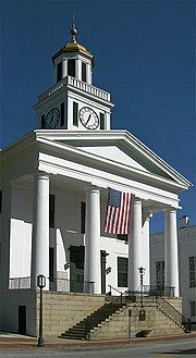
Maysville Downtown Historic District
Historic district in Kentucky, United StatesThe Maysville Downtown Historic District or "downtown" is the area first settled and developed. Situated in the western part of Maysville, Kentucky, United States, the downtown is defined by a grid of streets laid out parallel to the northwest–southeast curve of the Ohio River. The area is essentially rectangular, four and a half blocks long and two to two and a half blocks wide. Its western edge is marked by Wall Street and its northern extent by West Front Street and McDonald Parkway. Its eastern and southern boundaries generally conform to the rear property lines of buildings on the east side of Limestone Street and the south side of Third Street respectively.
Read article
Top Questions
AI generatedMore questions
Nearby Places

St. Patrick's High School (Maysville, Kentucky)
Private, coeducational school in Maysville, , Kentucky, United States

Washington Opera House
United States historic place

Lee House (Maysville, Kentucky)
Historic house in Kentucky, United States

Russell Theatre
United States historic place

Phillips' Folly
Historic house in Kentucky, United States

Courthouse Square and Mechanics' Row Historic District
Historic district in Kentucky, United States

Old Library Building (Maysville, Kentucky)
United States historic place

Cox Building (Maysville, Kentucky)
United States historic place


